

Posted: 6:30 am on 31 July 2024
This is your Prepare Now Message (PNM) for Wednesday, 31 July 2024, for the potential for severe weather.
Summary:
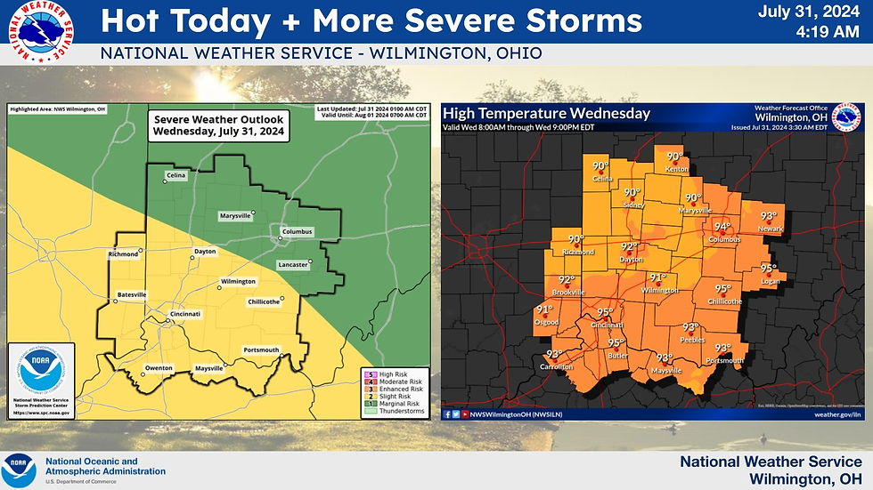
Clinton County is in a SLIGHT risk for severe weather.
Heat indices may be near or in excess of 100F.
Primary threat is Straight-Line Winds, which could lead to tree and powerline damage.
Isolated Tornadoes are possible (<2% risk for Clinton County at this time).
Timing for our area will likely be between 4 pm and 8 pm.
Special Weather Statement for Clinton County (link): The combination of heat and humidity will lead to heat index values near 100 degrees this afternoon. Use caution if planning to be outdoors.
Hazardous Weather Outlook for Clinton County (link): Showers and storms are likely late this afternoon through this evening, with strong to damaging winds and locally heavy rain being the primary threats.
Analysist Note: If you are still conducting recovery from the 30 July 2024 tornado, prioritize health by staying hydrated and taking breaks to avoid heat-related illnesses as heat index values near 100 degrees, and be prepared for potential thunderstorms with strong winds and heavy rainfall this afternoon and evening in Clinton County.
Recommendations: Review actions for keywords SEVERE, TORNADO, and POWER at https://cc-ema.org/prepare and stay weather aware!
NWS OnePager graphic:

NWS social media graphics:

NWS weather graph (as of 6 am Wednesday):

Storm Prediction Center graphics:
DAY 1 Wind Outlook (15-29% risk for damaging winds)

DAY 1 Tornado Outlook (<2% risk).

DAY 1 Hail Risk (<5%).

[END]
Comments